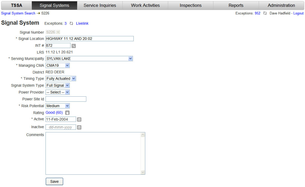
The General area of the Signal System screen is used to record basic information that would typically not change during the life of the signal system.
Information such as; the physical location of the signal system on the network; the date the signal system went into service and the company supplying the power to the site.
|
Field |
Description |
|
Signal Number |
System generated at the time the Signal System was created in TSSA. The Signal Number is in the format S999 (i.e. S061). |
|
Signal Location |
Signal Systems are located at Intersections or MidBlock. Intersections of significance have been assigned Site Numbers and given Location Descriptions. Signal Systems located at an Intersection Site are automatically populated with the Intersection Site's Location Description. The Signal Location can be edited. Signal Systems located Midblock have the Signal Location manually entered. See: Signal Location Guidelines for suggested standards. |
|
INT # |
The Intersection Site Number (i.e. 872) is the same number referencing a specific intersection used by other TIMS applications (i.e. WebMap). Entering the Intersection Site Number when creating a new Signal System will automatically populate the Signal Location, LRS, and CMA fields. If the Intersection Site Number is not know, the Intersection Search |
|
LRS |
The Linear Referencing System is a combination of values: road, control section, roadway label, kilometer post. When the signal system was created in TSSA, the LRS value was automatically calculated if an Intersection Site Number was entered or manually entered if Midblock. |
|
Serving Municipality |
The Serving Municipality is the municipality that is served by the signal system (i.e. the municipality that the signal system is located in). |
|
Managing CMA |
The CMA is automatically populated when the Intersection Site Number or the LRS is entered. The Managing CMA field may be edited as the CMA that 'manages' the signal system may not be the CMA that the signal system is physically located in. |
|
District |
The District is calculated using the Managing CMA value. |
|
Timing Type |
The Timing Type will be one of the following values:
|
|
Signal System Type |
The Signal System Type will be one of the following:
|
|
Power Provider |
This is the electric company that supplies power to the signal system. This is not always the wire provider. |
|
Power Site ID |
This is the power providers method of identifying power sites. The Power Site ID can be found on the monthly power bill. The bill identifies the charges for each power site id. The power site id's do not reference the LRS so contact with the power company may be necessary in determining which power site id relates to which signal system. |
|
Risk Potential |
Risk Potential considers the impact that may result if a traffic signal system malfunctions. The criteria used to determine the Risk Potential selection are: High Risk
Low Risk
Medium Risk
|
|
Rating |
Rating is an overall rating of the signal system based on the condition of the main equipment. See: Rating Calculation for an understanding of how the rating is determined or view the Change Equipment Condition procedure. |
|
Active |
This is the date the signal system first went into service in the field. |
|
Inactive |
This is the date the signal system was taken out of service (i.e. removed altogether as it was replaced by an interchange). The signal system is not deleted from TSSA as it was in service for a period of time and that historical information is required. |
|
Comments |
Each of the subsequent areas/sections of the signal system screen have a comments field. Therefore these comments are for general information (i.e. where supporting documents are stored). |
|
Button |
Description |
|
Exceptions
|
If a signal system has exceptions a number is displayed. This number is clickable and will display the exceptions (errors) that require attention. You can also view a 9 minute demonstration on exceptions: Exception Handling |
|
Revalidate
|
The Revalidate button will recalculate the Exception value. If changes have been made to a signal system's data the refresh will take those updates into consideration if exceptions are impacted. |
|
Livelink
|
The Livelink button will open Alberta Transportations Enterprise Information Management (EIM) portal at the location of the Intersection Site Number to provide access to any Engineering Drawings that have been stored. |
|
Intersection Search
|
The Intersection Search button allows the user to enter one or two roads as criteria to look up an Intersection Site Number. |
|
Save
|
The Save button commits the changes made to the fields in the General area of the Signal System screen to the TSSA database. |
 button can be used.


